This video, by Brett Foxwell, is a thing of beauty.
The Book of Leaves
This video, by Brett Foxwell, is a thing of beauty.
This video, by Brett Foxwell, is a thing of beauty.
For the last few years, our family has driven back and forth from our home in Wilmington, Delaware to Delaware, Ohio, as we have a child who has been a student at Ohio Wesleyan University there. Inevitably, I pay attention to the tracks that we cross going back and forth, and so I thought after years of googling these things in a haphazard manner, I would set out to catalog all the rights-of-way we cross on this journey. I realize the audience for such a list may well be one, and so be it. If this post turns out only to be if interest to me, I can live with that.
Here is an overview of the route. It’s about an eight hour drive.
It is pretty straightforward to note the active ones, but abandoned lines are much harder to catalog. In some cases, like Claysville, an old viaduct and a street named Railroad Avenue are both clear indications, but one is not always that fortunate. I find the terrain view on Google Maps, which seems to use Lidar data, to be very helpful, as there are many examples of rights of way that may no longer appear in visual imagery but nonetheless stand out in a Lidar view. I suspect that after I publish this, I will find that there are rights of way that I missed in my initial hunt.
I suppose I should start with the tools I use to determine what it is that I am crossing. For years, I have relied on Historic Aerials, which is a terrific site. They offer a lot for free, and I appreciate that, but they do not offer a paid tier that is appropriate to the hobbyist, which frustrates me. I would gladly pay a small fee to have access to a larger viewer and minimized watermarks, but I am clearly not their target customer. The ability to overlay the current road network on old topographic maps is incredibly useful. Still, my frustrations with their site have led me to the USGS’s TopoView site, which offers an amazing wealth of historic maps for free and viewable full screen. While it lacks the overhead photography of Historic Aerials, its maps are much easier to use. Needless to say, other key tools are Google, Wikipedia, and the countless web pages composed by enthusiasts of both rail and local history. Two sites in particular come up again and again in these searches – Greg Harrison’s Abandoned Rails and Forgotten Railways, Roads & Places. Both of these contain a wealth of useful information, and are wonderful starting points for finding and learning about the infrastructure that was all around us and now hides in plain sight. OpenStreetMap is another useful source of information especially to determine who owns an active line today.
I figure the simplest way to tackle this is to track the route I follow from east to west. Given that sometimes we stay on the Pennsylvania Turnpike for longer than others, I will include the two alternate eastern portions we cover, as I do not want to omit the tracks we cover on one versus the other.
As we leave Wilmington on the Lancaster Pike, we cross an active line currently operated by the East Penn Railroad. According to here and here, it began life in 1866 as the Wilmington & Brandywine Railroad which in turn grew out of the Delaware & Pennsylvania and the Berks and Chester Railroads. It commenced operations in 1871, and in 1877 reorganized as the Wilmington & Northern. Among the various industries it reached, it served the Dupont Company Hagley powder yards, so not unsurprisingly the du Pont family played a large role in its finances. In fact, Medal of Honor recipient Henry Algernon du Pont served as president of the W&N following his retirement from the U.S. Army until 1899. Presumably not coincidentally, the end of his term is when the Reading gained control of this line, which operated it as its W&N Division. Like so many northeastern railroads, the W&N was mauled by Hurricane Agnes in 1972, and the portion north of Coatesville, Pa. was never reopened.
Right out of the gate, we run into the fact that as soon as one starts googling things that occurred in the nineteenth century, if you consult two sources, you will likely obtain two sets of facts. I am going to try to avoid running down every little thing, not because I do not value accuracy, but here the perfect will truly be the enemy of the good.
The next two lines we cross are on and the same – the Wilmington & Western. Today this is an excursion railroad which I rode as a kid and now my kids have, too. To quote from the history compiled by the current operators here, “The Wilmington & Western Railroad was chartered in 1867 to move goods from the mills along the Red Clay Creek to the Port of Wilmington, and officially opened for freight and passenger service on October 19, 1872. … Excessive construction debts and poor management caused the line to fall into foreclosure in 1877, just a few years after opening. New owners reorganized the line as the Delaware Western Railroad, which became highly profitable moving kaolin clay, vulcanized fiber materials, snuff, iron and coal to and from the many mills that lined the route. … In the 1880s, the line was purchased by the Baltimore & Philadelphia Railroad (B&P), a subsidiary of the Baltimore & Ohio (B&O). Purchase of the line by the B&P provided the Baltimore & Ohio with an access route to compete with the Pennsylvania Railroad for passengers and freight traveling between Washington, Baltimore, Philadelphia and New York City. The line became known as the “Landenberg Branch” by the B&O and was, for a time, its most profitable branch line. … With trucks and automobiles gaining in popularity, the Landenberg Branch saw a sharp decrease in freight traffic, and the line was first shortened to Southwood, Del., in the early 1940s, and shortened again to Hockessin, DE, in the late 1950s.” This line suffered grievously in 1999 when Hurricane Floyd deluged the Red Clay valley, destroying two bridges and damaging eleven others. Four years later, Tropical Storm Henri destroyed six more bridges. Through great dedication, the WWRR managed to reopen its tracks north to Hockessin in 2007. A map of the now abandoned portion west of Hockessin, along with some pictures, is here.
The next line we cross is also part of the East Penn Railroad, but unlike the W&N which became a Reading line before Conrail, this line has a heritage associated with the Pennsylvania Railroad. Wikipedia alludes to this line building on a predecessor line called the Baltimore & Philadelphia Railroad, and directs the reader here to learn more, and I must confess I could not quite follow it all. The B&P started its construction in 1857, and began operating a portion of their planned line in 1858, when the line was bought by the Philadelphia, Wilmington & Baltimore (which called this line their Central Division), which this source says was in turn bought by the Pennsylvania Central in 1881. [Curiously, Wikipedia’s PW&B article says the PW&B merged into the PRR in 1902, with no mention of a Pennsylvania Central. I regret I do not have it in me to disentangle this.] The P&BC aimed to reach from Wawa, Pa. to a junction with the Northern Central near Baltimore, but would ultimately only build to the northern bank of the Susquehanna. There it connected with the Columbia & Port Deposit and then crossed the Susquehanna on the PW&B bridge, the pilings of which one can see today just south of the former PRR bridge that Amtrak uses to cross that river. Today this line runs from Sylmar, Pa., near Rising Sun, Md. over to Chadds Ford, Pa. Hurricane Agnes severed the line in Chadds Ford, and now the Octoraro Branch ties into the W&N at the former junction between the two lines. The abandoned eastern stretch from Wawa to Chadds Ford is discussed here, and the abandoned western segment from Sylmar to the Suquehanna can be found here.
Just north of Avondale, our route takes us over the Pomeroy & Newark. Built around 1870, here is Wikipedia’s summary: The Pomeroy and Newark Railroad was the final step in a series of consolidations and a foreclosure. The earliest predecessors were the Delaware and Pennsylvania Railroad, incorporated February 1857 in Delaware, and the Pennsylvania and Delaware Railroad, incorporated August 1868 in Pennsylvania as the Doe Run and White Clay Creek Railroad, and renamed August 1870. The two companies completed a line from Pomeroy, on the Pennsylvania Railroad’s Main Line, south to Newark and southeast to Delaware City on the Delaware Bay, in about 1873, and merged in May of that year to form the Pennsylvania and Delaware Railway. This company’s property was sold at foreclosure in August 1879 to two new companies, the Pomeroy and State Line Railroad (incorporated February 1880 in Pennsylvania) and the Newark and Delaware City Railroad (incorporated April 1880 in Delaware). After the former sold the line southeast of Newark to the PW&B, which it crossed at Newark, in 1881, those two companies merged in December as the Pomeroy and Newark Railroad. It became part of the PRR, and in December 1917 the line was sold to the Philadelphia, Baltimore and Washington Railroad, Pennsylvania subsidiary and successor to the PW&B. Ownership of the line between Newark and Delaware City went to Norfolk Southern (NS). The line is still used as far as the oil refinery west of Delaware City, and the section of roadbed which once extended past the refinery to the waterfront is Delaware City was abandoned.
The sixth, seventh, eighth, and 107th lines crossed in this outing are all Amtrak’s Keystone Corridor, which is an electrified line connecting Harrisburg and Philadelphia. This line is the former Main Line of the Pennsylvania Railroad, and before then it was built as part of the Philadelphia & Columbia, which commenced operations in 1832. The photographer Michael Froio notes here that the P&C became part of the PRR in 1857, and the portion of the P&C from Philadelphia to Lancaster was then joined to the Harrisburg, Portsmouth, Mountjoy & Lancaster to form the route as it is known today. The road crosses this route just east of Atglen, which is where the 1906 Atglen & Susquehanna low grade line headed west from the original PRR Main Line. Like a number of other routes covered in this summary, the old PRR Main Line evolved from the PRR to the Penn Central and ultimately to Amtrak. Its electric catenary system is unusual and distinctive, and makes spotting its progress along the landscape an easy task.
Following immediately on the heels of the last one comes the New Holland Secondary, now owned by NS. The line runs today from Lancaster to New Holland, and formerly connected from there to Downingtown. To understand its history, one needs to figure out that one of its incarnations was the East Brandywine & Waynesburg, and that Waynesburg is now called Honey Brook. Also known as the Downingtown & Lancaster, and tagged with the nickname the Dark & Lonely, it started in 1854, and first connected with the PRR Main Line at Downingtown to Waynesburg in 1861. By 1876, trackage extended west from Honey Brook to New Holland and the PRR acquired it in 1903. The Penn Central abandoned much of it in 1972. Abandoned Rails discusses it here, and Michael Froio does so here.
The next crossing is over an active freight branch that is a portion of a larger, abandoned line called the Reading & Columbia, which Abandoned Rails covers here. Chartered in 1857, operations began in 1864. This line branches off of the Lebanon Valley’s line near Sinking Spring, and heads southwest via Reinhold’s, Denver, Ephrata, Lititz, Manheim, and onto Columbia, with a 1866 branch to Lancaster after Manheim. There’s also a branch to Marietta, discussed here. Just to the west of Akron, along Middle Creek, one can see a trace of a branch line headed south that I do not see on any of the USGS maps. A good example of how some things come and go too fast to be recorded. There is a great history to be found here.
It seems that iron ore was found in Cornwall in the 1730s, leading to years of intense effort to extract this valuable commodity. By 1848, a plank road was in place, and not surprisingly the North Lebanon Railroad was put into place in 1855, changing its name to the Cornwall Railroad in 1870. The line at issue here is the 1883 competitor to the Cornwall Railroad, called the Cornwall & Lebanon. These two roads had such a rivalry that there were frequent races along the parallel rights of way, not unlike the Pennsylvania and Reading trains serving Atlantic City. In 1913, the PRR began acquiring an interest in the C&L, and completed this purchase in 1918. Once again, this line soldiered on until 1972, when Hurricane Agnes damaged it beyond economic repair. For much of this summary, I am indebted to this source. Curiously, this large operation makes no appearance on the Abandoned Rails site. (I say this not as a criticism, but simply to note that no one source is comprehensive.)
The next crossing is owned by the Middletown & Hummelstown, which has operated this former Reading property since 1976. Their web site offers the following history: The original Middletown & Hummelstown Railroad Company was formed in 1888 by local businessmen. Construction of the line between its namesake boroughs was completed in 1890. From then until 1976 it was part of the Philadelphia & Reading Railroad, later the Reading Company. Since 1976, the current Middletown & Hummelstown Railroad has been an independent company operating the seven-mile line providing freight service. Tourist passenger train service was begun in 1986.
This one challenged the framework I have adopted for this post, as I think it is fair to say that this line and the next were built as one line, but the evolution of ownership has fractured that into two routes. To explain, in 1838 the Harrisburg, Portsmouth, Mountjoy [sic] & Lancaster began operations. (Interesting explanation of the origin of the name Mountjoy here.) In 1850, this same line built a branch south along the east bank of the Susquehanna River south to Columbia, where it connected to the Philadelphia & Columbia discussed in #6, 7, 8, and 107 above. This road became the Main Line of the PRR between Philadelphia and Lancaster, and in 1849 the PRR leased the HPM&L, and then merged it into the PRR in 1917. Today, Amtrak owns the Keystone Corridor which is the inheritor of the PRR Main Line, but NS operates the 1850 branch as the Royalton Subdivision. Thus, these lines started as one operation and are today two.
See the text for #14 above.
Railroads seek flat routes, and so does water. For this reason, railroad often hug the banks of rivers, creeks, and streams, and this pattern has been clear in the routes we have looked at so far, including the Wilmington & Northern along the Brandywine, the Wilmington & Western along the Red Clay Creek, the Pomeroy & Newark along the White Clay Creek and Buck Run, the Downingtown & Lancaster also along the Brandywine, the Reading & Columbia along Chiques Creek, the Cornwall & Lebanon along the Conewago, the Middletown & Hummelstown along the Swatara Creek, and then the Harrisburg & Lancaster along the Susquehanna. The larger the river, the more intense the drive was to serve that commercial artery, so it is no surprise that the banks of the Susquehanna were prized locations. We looked at the eastern shore in #14 and 15 above, and #16 brings us to the York & Cumberland. To be understood, this operation needs to be seen as part of a larger effort by commercial interests in Baltimore to reach the Susquehanna. Pennsylvania interests were not keen to have their goods reach the Chesapeake, preferring Philadelphia instead, so politics played a role in how this played out. The Baltimore & Susquehanna received a charter from Maryland in 1828. For this plan to reach fruition, the line would need to enter Pennsylvania, and this took years to accomplish. The B&S reached York, Pa., via the York & Maryland, in 1838. For some time, the route to the Susquehanna flowed east over the Wrightsville, York & Gettysburg, which was completed in 1840. This route reached the Philadelphia & Columbia via the second bridge between Wrightsville and Columbia, but concerns about locomotive cinders on this wooden structure meant that the trains crossed the river dragged by oxen – clearly not ideal. Thus, the York & Cumberland received its charter in 1846, and opened for operation in 1851 on a route north from York to Lemoyne, across the river from Harrisburg. For a time it was operated by the Cumberland Valley Railroad (more on this later), but soon it was absorbed into the B&S. Financial woes in 1853 led to the consolidation of the B&S, Y&C, and two other lines forming the Northern Central Railroad in 1854. The NCRR would operate as far north as Sunbury, Pa. The PRR acquired controlling interest in the NCRR in 1861, which operated its routes until the Penn Central and Conrail era. Like others lines discussed today, the NCRR lines were badly damaged by Hurricane Agnes in 1972, and many were never restored to service following that storm. In the entry for #6, 7, 8, and 107 above, I mentioned the Atglen & Susquehanna line which the PRR built in 1906. It travelled west from Atglen, Pa., reached the Susquehanna at north of Pequea, Pa., and hugged the eastern bank north until the Shocks Mills Bridge, another structure damaged by Agnes, until joining the old Y&C alignment at Wago Junction.
This one is tricky. I can start with the fact that OpenStreetMaps refers to it as the Lurgan Branch, and Wikipedia offers an entry for this here. Without citation, this entry says the H&P was built in the 1870s from Lemoyne to Shippensburg. The Southampton Township of Cumberland County has a page here that offers some more detail – the road was formed in 1870 as the Miramar Iron Company to move iron ore. It then became the H&P with plans to extend as far south as Sheppardstown, W.V. In 1892, it became the Harrisburg & Shippensburg. This name led me to a summary on Wikipedia of an Interstate Commerce Commission document that offers the following corporate evolution: Miramar Iron Company 1870-1871; Harrisburg & Potomac 1871-1890; Harrisburg & Shippensburg merged with Harrisburg Terminal Railroad 1890; and then the Philadelphia, Harrisburg, and Pittsburgh starting in 1890. This page refers to the Philadelphia & Reading acquiring the PH&P in 1890. The oldest TopoView map for Lemoyne is 1906, and on that map this road is shown as the PH&P Branch of the Reading. The PH&P built the 1891 bridge over the Susquehanna that still swerves this route. Following my rules in this exercise, I will refer to this line as the H&P. (Since this is the first time I am mentioning Pittsburgh, I should also note that the city has not always had an H in its name. You can read all about this evolving state of affairs here, but suffice it to say that I am going too use the spellings that seem appropriate to the usage, and that may not always make sense, but there’s an attempt at reason here.)
This line is a branch to the Cumberland Valley Railroad, and as the main line of the CVRR appears in the next entry, I will skip over the history of that line for the moment. One source offered the best information I could find, so I will borrow from them for the following: The Dillsburg and Mechanicsburg Railroad was built with the backing of the Cumberland Valley Railroad primarily to haul iron ore from the vast reserves around Dillsburg to furnaces in the Harrisburg region. There were earlier attempts to build a railroad between Mechanicsburg and Dillsburg but they had been blocked by the CVRR. … Construction was completed by October 1872 and the line was operated by the CVRR under a 99 year lease. It was intended to be a feeder line for the CVRR. Abandoned Rails covers it here. (As an aside, there is a serious roller coaster in Williams Grove (40.15, -77.03) at the amusement park that closed in 2005. Amazing what you find rummaging through Google Maps.)
From this page, I gather the following: In 1895 the Valley Traction Company, realizing the commercial possibilities of the lake area, laid a trolley line from Carlisle to Boiling Springs. In 1900 Valley Traction leased the lake and created a delightful picnic grounds and pleasure resort. This park made Boiling Springs a popular vacation and holiday spot and a prestigious residential community. Trolley lines were extended throughout the valley and crowds traveled regularly from Carlisle, Mechanicsburg, and Harrisburg to enjoy the many attractions of the lakeside park, which included dances, picnics, a deer park, a merry-go-round, a small train, novelty stands, refreshments, sports and pleasure boating. In 1926 the trolley service began to dwindle and was eventually stopped in 1930 when the park was closed. The only park buildings still standing are the Park Novelty Store, now a private cottage, and the Dance Pavilion, now the Yellow Breeches Fly and Tackle Shop. The line continued in Route 641/Trindle Road/Main Street, and ultimately reached Harrisburg. I am surprised how difficult it is to track down more information on the line, and ultimately streetcars and trolleys are not meant to be the focus of this effort, so having allowed myself to be stalled by this for some time, I am going to leave this entry here. Should anyone read this (admittedly unlikely), perhaps this will strike them as a stepping off point for their own internet digging.
Another truly old line – the Cumberland Valley Railroad held a charter dating to 1831. Operations from Chambersburg started in 1837, and their Susquehanna crossing was complete in 1839. A sister operation extended the line from Chambersburg to Greencastle in 1837 and then to Hagerstown in 1841. In 1865, the CVRR absorbed this affiliate. This route was attacked by Confederate cavalry, first in June 1863 in the run up to Gettysburg and then again in July 1864. In 1873, the railroad extended its terminus south to Martinsburg, and then again in 1889 to Winchester via the Martinsburg & Potomac. Having controlled the CVRR since 1859, the PRR completed its purchase of the line in 1919. The portions that still operate are owned by NS, and Abandoned Rails covers a part of this line here.
I consider this to be the most peculiar entry on this list. Starting with Wikipedia makes as much sense as anything. Pennsylvania issued a charter to a group planning a Duncannon, Landisburg & Broad Top route in 1854. The group changed name and routes several times over the next few years, and they did grade approximately two miles of their planned route. By 1863, they had adopted the name South Pennsylvania Railroad. After nine more years passed with no progress, this outfit sold off the two miles they had graded. Here is where things get interesting – two of the largest railroads in the east were the PRR and the New York Central. PRR moves into New York angered William Vanderbilt, who owned the NYC, and so Vanderbilt developed a scheme with two Pittsburgh tycoons – Andrew Carnegie and Henry Clay Frick – to challenge the PRR in Pennsylvania and provide a non-PRR route between Pittsburgh and New York via the Reading and Jersey Central. This group bought the old South Pennsylvania charter in 1882, and in 1883 began in earnest to resume work on this long route. With a goal of a shorter, flatter route than the PRR’s existing offering, the SPRR planned nine tunnels through the Alleghenies and then a 26-mile section in the Cumberland Valley that would be straight as an arrow. After several years of construction, the PRR’s efforts in New York and the NYC’s SPRR construction had led to turmoil and financial difficulties for both organizations, and for J. P. Morgan. Thus, Morgan brokered an 1885 truce (on his yacht, of course) between the two railroads in which the PRR bought out the SPRR and the NYC leased the PRR line in New York that vexed them. Just when calm was set to be restored, Pennsylvania filed suit to block the PRR’s acquisition of the SPRR. Thus, with no further interest by its old owners and no new owner, work stopped on the SPRR route on September 12, 1885. The route lay dormant for decades until Pennsylvania’s interest in building a cross-state highway led to them acquiring the rights to the route in the 1930s. As late as 1938, the Interstate Commerce Commission denied an application by someone intent on building a railroad along the SPRR right of way. The Turnpike used seven of the nine tunnels bored for the SPRR: Laurel Hill, Allegheny Mountain, Rays Hill, Sideling Hill, Tuscarora Hill, Kittatinny Mountain, and Blue Mountain. Subsequent work to the turnpike has bypassed a number of these, and planners are evaluating how to expand the Allegheny Mountain Tunnel. There are some wonderful pictures of the unused or bypassed SPRR tunnels here. People always find ruins fascinating, and ruins usually come from a distant past or a different culture. There is clearly something compelling about this incomplete right of way which is not that old and from our own past, as it has rabid enthusiasts online. Abandoned Rails has some pictures here.
Wikipedia’s brief entry here boils down to the following: the Bedford & Bridgeport Railroad opened from Maryland/Pennsylvania border north via Bedford to Mount Dallas in 1871. Its southern terminus was Bridgeport, which is now known as Hyndman. The entry for the Huntingdon & Broad Top Mountain Railroad, which operated from Everett (originally called Bloody Run) north to Huntingdon, indicates the the PRR took over the B&B in 1872, having supported its creation as a way to access coal fields that had previously only been served by the B&O. Under the PRR, the B&B was known as the Bedford Branch. As the Pennsylvania Turnpike passes through the narrow just tot he west of Everett, it passes the former river crossing of the Bedford Railroad Company, which would later be joined to the H&BTM. I tried hard to justify separate entries for those operations, but as the route passes next to them, and not over, I am simply mentioning them here.
From the same B&B wikipedia entry as above: the Dunning’s Creek Branch, later part of the main line, opened from Dunning’s Creek Junction (near Bedford) north, through Cessna, to ore mines at Holderbaum in 1873. A 1908 map suggest to me this is near Swamp Bottom Lane. The same sequence of maps suggest that at some point between 1947 and 1953, the line was extended north to Queen’s Station, Sproul, Claysburg, East Freedom, and then a bit north of there where it joined the line that connected Hollidaysburg, McKee, Roaring Spring, Curryville, and Martinsburg. It seems this line may have been called the Morrison Cove Branch. This other page suggest the connection was made in 1910, which makes more sense to me but is at odds with the maps. The Everett Railroad timeline here confirms 1910. This page suggests that the H&BTM resisted PRR efforts to acquire them, and that the line north of Imler was built to punish the H&BTM, which went out of business in 1954, so that timing lines up. This is a good example of when I throw my hands up and move on. Abandoned Rails has some pictures of this line here.
The next rails we cross are the S&C Subdivision of CSX, which takes its name from the Somerset & Cambria Railroad of roughly 1881, which stretched from Rockwood in the south to Johnstown in the north. Rockwood, formerly Mineral Point, formed a junction with the Pittsburgh & Connellsville Railroad, which was completed in 1871. The Somerset & Mineral Point also started operations in 1871. The P&C was affiliated with the B&O property, and the B&O acquired the S&MP in 1879 with the goal of extending it north to a junction with the PRR in Johnstown. This northern extension was built in 1881 as the Johnstown & Somerset, and at some point soon after the southern and northern portions were combined into the Somerset & Cambria.
There is not a lot to go on with this one – Abandoned Rails traces it here, and refers to it as a B&O property, jointly operated with the Quemahoning Branch. This clue led me to a page which offers the following: The Baltimore and Ohio Railroad Company realizing the economic importance of the Boswell mine constructed a branch line in September 1902. The Quemahoning branch extended from Frieden to Boswell, on the Somerset & Cambria branch of the Baltimore and Ohio. Shortly afterward, the B&O Railroad opened a large and commodious station providing daily rail service for both coal and passengers. The station included a waiting room, ticket office and freight house and was heated by steam generated at the company’s powerhouse. The depot, no longer extant, was constructed on Atkinson Way behind the mine superintendent’s house. I have traced a whole loop, as the right of way is plainly visible, yet Abandoned Rails and this text suggest it was not a loop, and there was a junction with a Western Maryland line near Gray. Again, this is an opportunity for someone else to nail it down; I am simply going to throw my hands up.
This route is tricky as a portion of the alignment is the present day Turnpike, and was also planned for the SPRR. If you recall, Morgan imposed a settlement on the NYC and PRR in 1885, and the right of way sat in its impartially completed state fourteen years later when a group, including Andrew W. and Richard B. Mellon, pursued the idea of a railroad the connect Ligonier with Somerset. The group also included the Byers-Allen Lumber Company. This road would connect with the Ligonier Valley Railroad in the town of the same name and the B&O in Somerset. The railroad commenced operations in 1906, and lasted only ten years, ceasing in 1916.
This seems to be a coal railroad, and my sense from the sources I have stumbled on is that coal lines seem to place a lot of rail and move it a lot. The traces here are clear, and lead me to Abandoned Rail’s page about this line. I found an eight year old page here that discusses these lines – they all seem to be owned by the PRR, and the array fed into the PRR at Youngwood. The author cites an 1888 reference in the Official Railway Guide of that year. The two sources suggest abandonment by the 1950s or 1980s, and that’s about all I can offer here. When I look at the 1:24,000 map from 1965, the details there help a great deal. They show the full extent of the Boyer Run branch running to a site labeled as Strip Mine and Triple Slag Dump north of Mt. Joy.
I feel like this line must be related to the Boyer Run Branch, but the 1:62,500 1902 through 1958 topographic maps give no hint of it. The 1953 and 1954 1:250,000 scale maps suggest a possible connection, but it’s routing does not line up all that cleanly. The 1:24,000 map from 1965 offers details that help with 45 but no luck with 44. 45 is labeled as ABANDONED, but the map shows it running from Southwest down to just north of Mt Pleasant. Given that the Sewickley Branch is PRR, and that the connection south is to the Southwest Pennsylvania Division of the PRR, I feel like this is likely a PRR connection between these two territories, but it is frustrating not to have any more details to go on. I suspect there is a PRR branch line expert out there who would scoff at my ignorance, but there are limits to what I can dredge up.
This next line is active, and appears on OpenStreetMaps as the Radebaugh Subdivision. It is currently operated by the Southwest Pennsylvania Railroad, whose timeline can be found here. They seem to have taken their name from this trackage’s old name as the S.W. Pa. Division of the PRR, which is how it appears on the 1902 USGS map. This is where things get tricky, as the Wikipedia entry for the SWPRR makes no reference to anything before 1995, which is not helpful. If one traces the line south on that 1902 map, one reaches Connellsville, with an intersection with the B&O. Both lines then ran south to Uniontown, where they seem to have connected with smaller lines. A thread here suggests that the PRR bought the Southwest Pennsylvania Railroad, with no dates given. And here we find some answers (and a lot of pictures): the Southwest Pennsylvania Railroad was incorporated March 16, 1871. It was authorized to build from the Pennsylvania Railroad connection at Greensburg by way of Connellsville to Uniontown and on south to the Pennsylvania/West Virginia state line. In 1875 the line had reached Connellsville as far as Mount Braddock and in the fall of 1876 was opened as far as Uniontown. The Uniontown and West Virginia Railroad Company who started building the line further south. Before they could finish building the line, it was sold to the Southwest Pennsylvania Railroad who completed the line from Uniontown to Fairchance. I cannot quite figure out when the PRR acquired the SWPaRR.
The next line looks to be a branch off of the SWPRR mainline discussed above. It does appear on USGS maps in 1953, although it was not present in 1950. At that time, it was not just a stub branch or siding, but a connection over to Cowansburg, where it appears between 1949 and 1953. The line there is another PRR property where the Hempfield Branch comes in from the east and the Youghiogheny Branch comes down from the north. These follow the Sewickley Creek to the Youghiogheny River, where there is a junction with the B&O. (These names are all from the 1902 USGS map.) Abandoned Maps confirms this as the abandoned PRR Yukon Branch, with no details whatsoever. [This page tells me the Youghiogheny Branch started in 1873 as a narrow gauge line built by the PennGas Coal Company.] I wish I had more to offer here, but I also need to keep moving.
This next line, on the east bank of the Youghiogheny, serves today as the CSX Keystone Subdivision, which operates what was a Chessie property and before that the B&O Pittsburgh Line. And before that, it was the Pittsburgh & Connellsville, the following history of which comes from here: The Pittsburgh & Connellsville Railroad was incorporated in 1837 and 1846, and the extension of the line into Cumberland was authorized in 1853. Construction was started between Pittsburgh and Connellsville in 1847, and the Sand Patch Tunnel at the crest of the Alleghenies was begun in 1854. The line between Connellsville and West Newton was opened for traffic in September, 1855, and from West Newton to Port Perry, where a connection was made with the Pennsylvania in 1857. The line from Port Perry to Pittsburgh was completed and opened for traffic in October, 1861.
The now abandoned line on the west side of this same crossing appears on early nineteenth century maps as the Pittsburgh & Lake Erie, and the Wikipedia entry on that line offers the following about this portion: The Pittsburgh, McKeesport and Youghiogheny Railroad ran from 24th Street in Pittsburgh to Connellsville, Pennsylvania, in 1882. An interesting connection exists between the PMcK&Y and the SPRR. The last spot where we encountered the SPRR was #43, and it seems that the route was to run from near Donegal to Connellsville, where it was to cross the Youghiogheny and then run north on the PMcK&Y. It would be absorbed into the Pittsburgh & Lake Erie Railroad at some later point as the Youghiogheny Branch.
Looking through these various routes, I enjoy the ones that date to the earliest days of railroading. Yet there is a certain appeal to see an artifact of a railroad built in more recent times. You can see in the right of way the availability of earthmoving equipment that allowed different approaches to crossing the countryside and this next route is our best example of this on the journey so far. The Pittsburgh & West Virginia Railway was completed in 1931. Rail still reigned supreme when this route was conceived, and a group of affiliated railroads, owned for the most part by the Fuller syndicate, who wished to create a long distance connection needed to bridge a key gap from Pittsburgh to Connellsville did so with this route. This was part of something called the Alphabet Route, which challenged the supremacy of the PRR, B&O, NYC, and Erie systems. The central figure in this effort seems to be George J. Gould, son of the famous and notorious Jay Gould. He died in 1923 (in France, having contracted pneumonia while in Egypt visiting the tomb of Tutankhamen), but the appeal of his transcontinental system carried the eastern portion of it through to creation eight years later. The corporate roots of the P&WV date to 1904 when Gould and others were forming a Pittsburgh-Toledo Syndicate. Three railroads they were assembling – the Cross Creek Railroad in Ohio, the Pittsburgh, Toledo & Western in West Virginia, and the Pittsburgh, Carnegie, and Western in Pennsylvania were consolidated as the Wabash Pittsburgh Terminal Railway. This road entered receivership following the Panic of 1907. After nine years in that state, it was sold at foreclosure and reorganized as the P&WV Railway. The start of the route relied on the Wabash Tunnel across the Monongahela, which reached the West Side Belt Railroad. This line running from Temperanceville to Clairton served as the stepping off point for forty miles of track leading to Connellsville. (After I wrote all of the above, I later found a wonderful resource on this line, which is worth a link, here.)
On the eastern shore of the Monongahela River, we cross over a line that OpenStreetsMap calls the “Mon Subdivision.” Googling that seems to lead to the line on the western bank, so then I look back through the USGS maps and see we are back to the P&LE, which we encountered in #50, but this time their Monongahela Branch, built in 1901 according to Wikipedia. What is trickier is that Wikipedia says it was built south to Brownsville, yet the USGS maps show its southern terminus as Fayette City, at least until sometime between 1927 and 1931. When the portion south of Fayette City appears in 1931, it bears the NYC label and does indeed run south to Brownsville, where it met the PRR’s Redstone Branch (another abandoned line not referenced on Abandoned Rails).
After encountering several lines with limited information and spotty Wikipedia entries, the information available about this next line is nearly ideal. This line starts with an 1867 charter for a route connecting Pittsburgh to Waynesburg. Three years later, the company took the name Pittsburgh, Virginia, and Charleston Railway. By the time they commenced operations in late 1872, the PRR had assumed control. By 1879, the PRR had leased the PV&C and operated it as their Monongahela Branch, which is how it appears on the oldest USGS maps available online. By 1905, the PRR owned it outright, until the PC days in 1968. The PC had it until 1976, when it became part of Conrail, which lasted until 1999, when it became an NS property. (Incidentally, there is a very useful map of the PRR network near Pittsburgh on the PRRTHS site here.)
This track appears on OpenStreetMaps as the Ellsworth Secondary, and on old USGS maps as the PRR Monongahela & Washington Branch. Given how far west Washington, Pa. is from here, I am not sure if I am missing something big, or if the name was aspirational. The track terminates near Cokeburg in the 1901 through 1944 1:62,500 maps, but the 1951 1:250,000 shows the track extending south to Marianna, Pa. Abandoned Rails covers the southern portion here, but with no history of its origins. This is another case where I am sure someone who is an expert would scoff at my confusion, but I for the moment I am going to have to give up and move on without ascertaining this line’s origins.
This one has been a true, obscure challenge. It is vividly clear on the terrain maps and yet the USGS maps showed no hint of it until the 1950s when the mentioned it as a “abandoned grade.” I could not imagine how it could be abandoned yet omitted on the earlier maps. Much googling ensued, and then I finally came across this thread. In may 2007, user jrevans posted the following, citing a book called Three Feet on the Panhandle by Larry Koehler (you can buy a copy on Amazon for $764): The line in question was indeed the “Chartiers Southern” with an alignment … starting at VanEman (on the former Chartiers Valley RR) through Eighty Four, to Glyde (where the tunnel is) down to the PRR Marianna Branch. The book states that the B&O was supposed to have owned, and maybe built the Chartiers Southern from Eighty Four to Marianna, even though no physical connection existed in between the two railroads. The book says that the line was started South from VanEman in 1908. …this unfinished ROW was sold to the Monongahela Railroad on Feb 28, 1929 (along with the other C.S. lines). The page here cites 1917 as the year construction was abandoned. Newspapers.com has a 1915 copy of the Canonsburg Daily notes with an article about this line. The text anticipates a summer 1916 completion date, lists the length of the now-collapsed tunnel under Route 40 as 1,300 feet, and further states that the 18.65 miles required 44 bridges and 30 “heavy cuts.” The cost of the entire line is given as $2.6 million ($70.4 million today) The same article says survey work began in 1906, with construction beginning in April 1913. The author anticipates the eventual southern extension of this alignment into Greene County.
These western Pennsylvania lines are complicated. The early USGS maps of this spot show it as the B&O Pittsburgh & Wheeling Line. More digging in google reveals that this line started as a western portion and an eastern portion, with Washington, Pa. as the spot where the two sections met. An 1896 Sanborn fire insurance map in the Library of Congress matches this. I think that the earliest iteration of this route was as the Pittsburgh, Castle Shannon & Washington Railroad, which dates to 1876. The text I found on the history of this line, authored by Jospeh Brennan, describes its evolving route in ways that are hard to reconcile on the map. The author starts by saying it ran from Castle Shannon to Library in 1877, both of which can be found on the map and Library is close to the route later identified as the P&W on the early USGS maps, so that makes sense. Then he refers to the town of Upper Saint Clair, which is well west of the alignment. The route is described as heading southeast from Upper Saint Clair, following the Piney Fork to Library. It’s easy enough to find Piney Fork and make that connection, but by 1904 the USGS shows no trackage – active or abandoned – along the Piney Fork, so it’s tricky to know what to make of this. On the map I have placed a line from Castle Shannon to Upper Saint Clair, which passes the encouragingly-named “Washington Junction,” and then follows the Piney Fork until Bethel Park, where I have had it join the existing right of way there. Soon, it overlaps with the southern section of the Montour Trail and follows that to Library, and thence to Finleyville. In 1879, a change in management led the PCS&W to become the Pittsburgh Southern Railway. In 1883, the B&O acquired controlling interest in the PSR, and bought the road outright in 1884, after which it was reorganized in 1885 as the B&O Short Line Railroad. The B&O seems to have shifted its eastern terminus from Castle Shannon to Glenwood Junction, on the northern/eastern bank of the Monongahela River, and these two routes converge near South Park Township along Peters [sic] Creek. Brennan continues: “…by the time the B&O was ready to expand west from Pittsburgh … there were established routes along both sides of the Ohio River. The B&O was therefore forced to create two awkward routes that involved leaving Pittsburgh traveling east and then curving around to the north or south. Both were completed in 1884. … The B&O used the Pittsburgh Southern charter to construct a new railroad branching off at Glenwood, almost five miles east of the Pittsburgh terminal. It crossed the Monongahela on a great bridge, ran a few miles in the valley of Streets Run, and then curved its way through the hills to reach Finleyville on the original Pittsburgh Southern.” Brennan goes on to state that the portion of the PSR north of Finleyville was abandoned in 1884. The B&O merged this eastern portion with their Wheeling Division (see #59-65 below), so I have drawn in the eastern and western portions as one continuous line on the map.
Unlike some of the lines enoucntered here, with little or no information to be found, this line benefits from extensive coverage online. As usual, when there are multiple sources, many of the details do not always line up smoothly. Starting with Wikipedia, we gather that the initial charter was granted in 1831 but led to nothing. A second attempt occurred in 1837 and a third, more successful effort started in 1853. Construction was a third complete by 1856, but funds ran out. The concern was sold in foreclosure in 1861 to the PRR, and in 1867 the Chartiers Railway Corporation was formed. Service began along the whole line in 1871, and later in that year the property was leased to the Pittsburgh Cincinnati & St. Louis (which later became the Pittsburgh Cincinnati Chicago & St. Louis). Affiliated with the PRR, the PCC&StL acquired the Chartiers line outright in 1907. From the PRR, it became part of the PC, and then Conrail in 1976. Conrail sold it in 1996, and today the still active portions of the line are operated by the Pittsburgh & Ohio Central. Our second source comes from William Metzger at the Pennsylvania Trolley Museum. His summary includes the following: first survey in 1831, construction commenced 1853 and halted 1856, PRR acquisition in 1866, construction completed 1871. The line crossed Chartiers Creek creek 19 times and had two tunnels. The first tunnel was “daylighted” (made into an open cut) in 1898. The other tunnel, known as Bell’s Tunnel, or Greer Tunnel, is still in use; it was widened for a second track and lined with brick in 1895. The railroad was double tracked from Carnegie to Houston, 15 miles, by 1904. The third source is John Oyler, via the Bridgeville Area Historical Society, who focuses on the engineer who conducted the initial survey: Charles De Hass. His column offers tremendous detail on what was involved in surveying and estimating the costs for a railroad in the early days of the industry and is full of interesting detail – such as a $4,625 per mile construction cost estimate. A fourth source, supplied by James Herron, Jr., confirms much of the above but adds that there was an 1846 effort to pursue this line and that it was the Panic of 1857 that smothered the 1853 attempt. Finally, Peter Vanvliet’s timeline points out the importance of the narrow-gauge Waynesburg & Washington which connected to the Chartiers line in Washington. Its 28 mile run south offered important connectivity to this whole route.
This line is the western portion of the B&O Pittsburgh & Wheeling Line. The eastern portion is covered as part of the entry for #56, above. Google surfaced a December 1937 article in the Western Pennsylvania Historical Magazine by E. Douglas Branch called Pittsburgh and the “Terrible Hempfield.” This article explains that the political power of Philadelphia and the PRR had prevented the B&O from reaching western Pennsylvania for many years, fostering resentment in the west over their inability to access another route to market. This frustration seems to have dovetailed with Pittsburgh’s rivalry with Wheeling, which aspired to be the dominant city on the Ohio River. The initial 1850 plans for the Hempfield were to run from Wheeling to Greensburg, 26 miles east of Pittsburgh (Greensburg is also the northern terminus for the Southwest Pennsylvania Railroad found in #47). The threat here was to divert the PRR mainline from Pittsburgh to a more southerly route that would terminate at Wheeling. In 1853, the PRR’s chief engineer Edward Miller recommended investment in the Hempfield, further antagonizing Pittsburgh. This motivated Pittsburgh interests to invest in the Pittsburgh & Connellsville (see #49), which would enable the B&O to reach Pittsburgh. Another response in 1853 was for Pittsburgh interests to fund the Chartiers Valley Railroad (see #57 & 58 above), to siphon off Hempfield traffic northeast to Pittsburgh. In 1853, the Hempfield began construction, which continued until July 1854, when it suspended work for a year. The stretch from Benwood, south of Wheeling, to Washington opened in 1857. Ultimately, the B&O acquired this route in 1885, which is ironic given the initial fear that it would be a PRR property. A poster named Erik Neely wrote in May 2021 that the B&O acquired the line in 1859 and performed a major overhaul on it in 1906. Wikipedia cites 1871 as the year the B&O bought it. The site here notes that when work was halted in 1854, a great deal of work east of Washington had taken place and was abandoned, and it offers some good hints about the original planned route to Greensburg. That’s tangential to the point of my effort, but should it be of interest to you, by all means follow that link.
I have avoided filling this post with all the amazing documents, images, and maps I have come across, as I would never finish it if I did that, but I must include this 1897 bird’e eye map of Washington, Pa.

There is not a lot of material online about the Wheeling Terminal Railway, so I am borrowing wholesale from a post here: After a series of bankruptcies and consolidations between 1882 and 1889, the Wheeling Bridge & Terminal Railway (WB&T) was proposed to consist of 10½ miles of track from the Cleveland & Pittsburgh Railroad at Martin’s Ferry, Ohio to Wheeling via a 2,097-foot double-track bridge over the Ohio River, and three tunnels that are 537 feet, 1,203 feet, and 2,406 feet long, respectively. … The Ohio River crossing was designed by Job Abbott, a consulting engineer for the WB&T, built by the Edge Moor Bridge Works of Wilmington, Delaware [emphasis mine], and opened to traffic on September 11, 1891. After crossing the river, the WB&T crossed under Mt. Wood via a 537-foot and a 1,203-foot tunnel before crossing Wheeling Creek on a 320-foot deck truss bridge. The 4.7-mile line then connected with the Baltimore & Ohio Railroad (B&O) at 27th Street in Wheeling. A 2.2-mile extension from the B&O to the Riverside Iron Works, including a 2,406-foot tunnel under Chapline Hill, was finished by May 1895. The WB&T was then extended .38 miles south to 9th Street in Benwood by November 1896. The Mt. Hood tunnels were partially rebuilt in 1904. In January 1921, the Pennsylvania Railroad (PRR) took over operations of the WT. … In 1938, the last passenger train crossed the Ohio River bridge and tunnels and was outright abandoned in 1982. After 11 years of disuse, the Ohio River crossing was removed in 1993.
I labored over this one, and so I am going to take a moment to discuss why it was tricky and the assumptions I have made. In the discussion of the Hempfield Railroad above, I mentioned its western terminus of Benwood. When I surfaced that fact, I was surprised the line did not stop in Wheeling, and guessed that Benwood was chosen simply because it offered enough room for a yard. Now that I have been digging into the issue of Points 65 and 66, I think I have a better idea of what was going on. The B&O reached Wheeling from the south, via Cumberland, in 1853 (look at this gorgeous map) and this line terminated at Benwood. The Hempfield started from Benwood for this reason. The Hempfield line originally snaked through west Wheeling, entering via the Hempfield Tunnel. This tunnel is, like so many old railroad structures, alleged to be haunted by locals, who point to Wheeling’s need to relocate a cemetery when the tunnels as built. This article suggest a construction date in the 1850s, and includes a photograph with a 1904 date on it. This page explains that the tunnel was built by the Hempfield and rebuilt by the B&O in 1904. The USGS site does a wonderful job of allowing you to see a wide expanse of each old map at once, but it does not let you zoom in very close. Historic Aerials, on the other hand, allows much closer zooming and has some very helpful blending options, making it much easier to correlate features in one map on another.
This line appears on old USGS maps as the PRR, and it took a long time for me to unravel the history of this line. The presence of the Ohio River Railroad on this side of the river, which would later be absorbed into the B&O, muddied the issue, and led me down some blind alleys. Ultimately, this page by Dan Robie and an annotated map he created enabled me to understand the evolution of these lines. Wikipedia tells us that the Pittsburgh & Steubenville Railroad was chartered in 1849 to build between its eponymous cities, where it would meet the Steubenville & Indiana. In 1856, the PRR created a company called the Western Transportation Company to build and operate the P&S. Interestingly, the head of the S&I purchased land from 36 landowners across the sliver of Virginia (now West Virginia) which allowed the construction to proceed without a charter. The P&S bypassed Wheeling and thus Wheeling had worked against its creation., but despite their opposition, the P&S opened in 1865. This line’s passage over the panhandle of West Virginia gave the name Panhandle to the bridge in Pittsburgh where it left that city. I love that this name lingers to this day. From 1865 to 1868, these lines operated as the Pittsburgh, Columbus & Cincinnati, and then following a foreclosure and reorganization, they were combined into the Pittsburgh, Cincinnati & St. Louis. Separately, in 1868 the Pan Handle Railroad was formed, which adopted the name Pittsburgh, Wheeling & Kentucky in 1871. In 1872, the PW&K started building building from the P&S’s Wheeling Junction near Steubenville south to Wheeling. Work was suspended between 1873 and 1877. After entering into an agreement with the PRR, construction resumed and the railroad opened in 1878 under lease to the PC&StL. An additional four miles from Wheeling south to Benwood were built between 1879 and 1883. The B&O negotiated trackage rights over the PW&K.
(As an aside, I cannot tell you how glad I am to reach the western shore of the Ohio. This has been a much more involved exercise than I ever imagined when I started it.) The 1902 USGS map shows two lines on the western bank – and the first is the River Division of the Cleveland, Lorain & Wheeling, now part of CSX. Like so many railroads, it started under one name, and years later came to fruition under a different guise and serving different endpoints. In this case, Wikipedia offers that the effort began in 1870, and evolved through an 1877 charter extension to extend south to West Wheeling, and then in 1886, they extended the line even further south to Bellaire, Oh. This line was connected across the Ohio in 1898, and by 1901, the B&O had acquired controlling interest in the CL&W. By 1905, the B&O had completed a series of line upgrades which are detailed in a wonderful article found here. By 1963, the C&O had acquired the B&O, and then it became the Chessie System in 1973. In 1980, Chessie evolved into CSX. Today the line connects with NS at Elyria, the CSX Greenwich Subdivision at Grafton, the CSX Cleveland Subdivision at Medina, and is truncated at Sterling, Oh. The line can be easily traced south to Bannock but is harder to spot as it follows the Wheeling Creek east to the Ohio. Interestingly, the counties through which the line passes south to about Stillwater, Oh. supply Google with property line data, which makes right of way spotting a piece of cake. Alas, Harrison and Belmont Counties do not. Google Maps does not make county lines easy to fund, but there are services on the web that will show these borders overlaid. As an example of how useful the property lines can be, here is a look at Warwick and Clinton, Oh. – notice how clearly one can make out both the active and abandoned rights-of-way.

Old USGS maps shows this as a PRR railroad, called the C&P Division. Google fills in the banks and it appears this is a portion of the Cleveland & Pittsburgh. While this page offers a nice history of the C&P, it says nothing of this branch. It is currently part of the NS Cleveland Line, and the Wikipedia page for that speaks to this only in the briefest possible manner: The C&P was chartered in 1836… Construction of the line was completed in 1852, with additional branch lines to Akron and Wheeling. The PRR leased the C&P in 1971, and then it progressed through PC, Conrail, and then NS in 1999. By the early 1900s it extended as far south as Powhatan, but I have not been able to confirm any of these dates.
Early USGS maps show this is a B&O line, and Abandoned Rails has a 1936 abandonment application from the B&O that seems to correspond to this. The application refers to Neffs and Kimmel, and I cannot ascertain where Kimmel is. This page identifies St. Clairsville as having two stations: one for the CL&W in the center of town (extent and gutted, alas) and another for the Wheeling & Lake Erie (see #73) on the western side, situated on Station Street appropriately enough. From the former, we learn that the present St. Clair Street is most likely the old right of way and that what was known by the early 1900s as the B&O started as the CL&W. In #70, we learned about the B&O’s acquisition of that line, so now I am back to this 1901 map of the CL&W, which shows St. Clairsville as a city on its line, but served by a branch extending north from St. Clairsville to Barton. Given that I am interested in the line south of town, this is not helpful. I think this northern bit corresponds with the abandonment application Abandoned Rails has for the Saint Clairsville & Northern Railway, which appears on an old USGS map as a CL&W line. So assuming the St.C&N was bought by the CL&W, which was in turn acquired by the B&O, it would make sense for that B&O line to link up with the one from the south, and you can follow the run south from Barton along Town Run, meeting up with Legion Road and then meeting the southern route via Sugar Street. The 1905 USGS map does not show any linkage, so perhaps I am ahead of myself. A September 8, 2018 article in the Intelligencer lists St. Clairsville as having three depot – the two already listed and a third for the StC&N, so that suggests each line had its own station and that there was no connection. I am going to assume this is a CL&W branch later acquired by the B&O and leave it at that.
This was another tricky line to track down. The it is abandoned and the part crossed in this exercise is now part of the National Road Bikeway – opened in 1998, the only Ohio rail trail with a tunnel. The old USGS maps identify the route here as the Adena Branch of the Wabash Railroad. I was a little stumped when I looked at the system map for the Wabash on Wikipedia and saw no lines anywhere near this part of Ohio. The oldest of the various roads that coalesced into what would become the Wabash started in 1847, but it was an 1877 reorganization that created what is best known as the Wabash. The Wabash Terminal Railways was created in 1904 to enable the Wabash to reach Pittsburgh. In a later guise, we encountered the WTRy in #51 when it was known as the P&WV. The WTRy acquired control of the Wheeling & Lake Erie and this seems to be why this line shows up as a Wabash line on the USGS map. The Wabash Railroad entered bankruptcy in 1915 and reorganized as the Wabash Railway later that year. In 1927, the PRR acquired control of the line. Wikipedia offers no insight into this branch, so a little more googling brings up this page which says: In 1901, the Adena Railroad bought the Bellaire & Valley Junction Railway, a proposed twenty mile line extending from Adena south to Neff, Ohio. The W&LE, through the Adena, completed this line and placed it in operation on February 1,1903. I can find an early mention of the B&VJ in 1890, and Wikipedia shows it as existing from 1890-1901, also citing it as joining the Adena Railroad, which is shows as existing from 1901-1916, before joining the W&LE. Other than one dedicated modeler, there is very little to be found online about the Adena Railroad.
The density of railroads from Western Pennsylvania until now has made this slow going, so I am grateful for the long pause between the last point and the next line we encounter. I am also surprised, but I have scoured through the old USGS maps, the more modern small scale ones, and also the lidar data, and we do not run into another line until nearing Cambridge, Oh. The old maps show this as a B&O line and when one traces it east, it leads to Bellaire, across the river from Benwood. Some digging turns up that it was built as the Central Ohio Railroad, which obtained its charter in 1847 backed by Zanesville interests. Despite various difficulties, the first section opened between Zanesville and Newark in 1852 and the entire line opened in 1854. Via the B&O’s Benwood-Cumberland line, this enabled Columbus to reach the east coast by rail for the first time. The line entered bankruptcy in 1857, but war traffic allowed it to reemerge in 1865. The B&O invested in the line and then leased it (this page says the B&O acquired it in 1865). A third source gives 1866 as the lease date, and notes that the B&O changed the gauge of the CO from 4′ 10″ to standard gauge. I continue to try to resist posting all the fantastic documents I am uncovering, but the Library of Congress has an 1850 map of the Central Ohio that is too wonderful to ignore. The line heads west north of I-70 until it reaches the Muskingum north of Zanesville, and then the line dips south of the highway to cross the Muskingum and the Licking River, before crossing I-77 again just west of Zanesville. The route heads up the Licking River valley and was clearly realigned to accommodate the 1961 construction of Dillon Dam and the creation of Dillon Lake. The old and the new routes converge near Marne, and continue west where our route next crosses it as we head north on I-270 near Gahanna.

Having crossed six dozen sets of railroad tracks, this next set is a novelty as they are for an interurban train or a trolley. Looking for information on this line, I see there was a fatal accident at the north end of the line in Cambridge in 1908. The article refers to two lines: “the Byesville interurban and the city car.” The Bywesville Scenic Railway page has a picture of a trolley with this caption: The New Midland Power & Traction Co. operated between Cambridge and Pleasant City, Ohio. Although the line was abandoned in the 1920’s, much of the roadbed is still visible today. The alignment is on old USGS maps and shows the trolley using, or very closely paralleling, the rail line on the western side of the valley. Yet when one switches to the overhead view on Google Maps, and the schematic view with its property lines, the line is easily traced south through Byesville, to the standing piers of a bridge just north of Derwent, south to Pleasant City. Here is a picture of one the Cambridge & Byesville cars. At last, this page gives a good summary: [The Cambridge Power, Light & Traction Company] operated just seven miles between Cambridge and Byesville, opening in 1903. In 1910 it was purchased by the Midland Power & Traction Company, which two years later was changed to the New Midland Power & Traction company. It was able to complete a short branch to Pleasant City, about five miles, but was never able to gain an interchange with the nearby Pennsylvania Railroad. It was again acquired in 1915 by the Ohio Service Company, in whose possession it remained until abandonment in early 1927. This page gives 1929 as the year of abandonment. If you would like to see lots of historic pictures of Cambridge and read about political fights over machine shop locations, you will want to read this.
Appearing on old USGS maps as a PRR line, I traced this one south and managed to find an older one that referred to it as a PCC&StL line (which we last encountered along the Chartiers Creek). Googling that led me to the name Marietta & Pittsburgh, which in turn brought me to an online site run by the Hagley Museum, just a few miles from where I am sitting. Their 1945 record here explains this road was incorporated in 1868, and in 1872 they were filing to build five branches. They terminated under the M&P name in 1873, and became the Marietta, Pittsburgh & Cleveland, also in 1873. Their 1871 papers showed them operating between Marietta and Dennison, but in 1871 they shifted their northern terminus to Canal Dover. Work began in 1869, and the Marietta-Macksburg section opened in 1869. The whole 98 mile route north to Canal Dover opened in 1874. The same volume traces the MP&C through 1880, but Wikipedia shows that the MP&C became the Cleveland & Marietta Railroad in 1877 or 1879, which then became the Cleveland & Marietta Railway in 1886 (Hagley backs this up). It continued under that name until 1911, when it consolidated with the Toledo, Walhonding Valley & Ohio to became part of the Toledo, Columbus & Ohio River, which continued until 1924, when it became the Pennsylvania, Ohio & Detroit, which existed until 1956 when Wikipedia says it merged with the Connecting Railway. Page 165 of the Hagley book says that W&LE had controlled the C&MRwy prior to 1886, but that the PRR gained control in 1893. There is an astonishingly detailed 1871 map of the M&P at the Library of Congress. I suspect it could be the basis for multiple doctoral theses as it has a blizzard of lines all neatly labeled. A final comment, from deep in the weeds – there seems to have been some realignment between Kimbolton and Guernsey, as the original alignment loops well to the west, and then later the route shifted to the east. It seems like the property lines and the lidar data re out of registration here, as there is a pretty consistent east-west disparity between the two datasets. There also seems to be every indication of a tunnel splitting the hill, and yet I see no record of that on the USGS maps. Another mystery.
The next line started in 1875 as the Bellaire & South Western Railway (Wikipedia). Contraction began in 1876 at the eastern end of the line and reached its western terminus of Zanesville in 1884. For a time, the line was called the Bellaire, Zanesville & Cincinnati before adopting its final name, the Ohio River & Western, in 1903. By 1928, they were abandoning or selling off portions, and they ceased operations in 1931. The same Hagley reference text mentioned previously is useful again for some of the above dates. It’s abandonment that early, combined with it being a narrow gauge line, mean the alignment is difficult to discern on the landscape, so portions of the line for it on my map are more schematic than actual.
When one reaches Zanesville, you pass over the B&SW at Mill Run and then cross over the Central Ohio and another old line on the eastern bank of the Muskingum. The old USGS map says “PA SYSTEM C AND MV RR.” I do not quite understand how the USGS people decided to name the rail lines on their maps, but they sure are useful starting points. Still, I did spend a minute chasing down the Chester & Mount Vernon before realizing this line was the Cincinnati & Muskingum Valley. Wikipedia offers a very brief entry and Abandoned Rails offers nothing, but the FRR&P site has compiled a useful entry, which tells us: the C&MV connected Trinway and Morrow via Zanesville; it connected to the Cleveland, Akron & Columbus and both properties were affiliated with the PRR; it was incorporated in 1851, construction began in 1856, and was complete in 1870; in 1863 a reorganization led to it being renamed the Cincinnati & Zanesville; the PRR gained control in 1870 and extended it from Zanesville to Trinway; and it ultimately merged with the CA&C in 1911. Another page notes that 21 railroads obtained charters in Ohio in 1851, and only seven built their routes. This same page also supplies the line’s original name – Cincinnati, Wilmington & Zanesville.
This was another tricky one. The oldest USGS maps show it as the Wheeling & Lake Erie, so much googling had to take place before the story emerged. Curiously, I found three accounts, and while they are all very similar, they all differ in detail. Wikipedia has almost nothing to offer, but this Nickel Plate page offered some good clues. This led to Cleveland Memory which added more details, although several do not line up cleanly. The two most useful sources are American Rails and Abandoned. American Rails suggests that the line was called the Conotton Valley Railway when it reached Zanesville, but the other pages suggest it was either the Cleveland & Canton, or the Cleveland, Canton & Southern. At some point, the issue begins to resemble angels on the head of a pin. It does seem like this route extended south from Canton and reached Zanesville in 1885, and that the W&LE bought it in 1899. I must offer a thank you to Stephen Titchenal’s Rails and Trails site, which offers a wealth of maps, track charts, and valuation documents. If this is your thing, you will love what he has assembled.
In Cambridge, our route crossed a set of trolley tracks, and here in Zanesville we do so again. The Newark & Zanesville appears as a brief reference on this page as a predecessor to the 1904 Columbus, Newark & Zanesville line that consolidated several smaller operations. I mentioned in the discussion of the Central Ohio that construction of the Dillon Dam compelled that route to alter its alignment, and the dam would have also forced changes to this streetcar line, except it had ceased operating by 1929. This page suggests that the CN&Z was built in its entirety, rather than absorbing predecessors, so I am not sure how to reconcile those two statements. There is a nice collection of pictures of this operation here. A Columbus Messenger article says the Columbus – Newark portion came first, followed by a subsequent extension to Zanesville. There is a nice, annotated Google Map of the whole route here (amazingly, since being posted in 2015, 2.4 people per day have looked at that map). Bridgehunter notes two structures that remain from the line.
Old USGS maps show this as the B&O Newark and Shawnee Branch, and a google search for that brought me to Abandoned Rails’s Rock Run Branch page. The text here says that the route was conceived of in 1849 as the Scioto & Hocking, but not built until the Newark, Somerset & straitsville purchased the line and completed it in 1867. It heads south from Newark, where it branched from the Central Ohio, and crossed over the Cincinnati, Wilmington & Zanesville at Junction City, before heading south to a fork that served Straitsville on the west and Shawnee on the east. Along the way it pralalled the Zanesville & Western between Thornville and just west of Chalfants. In Shawnee, it ran into the Z&W again. Rails and Trails has a good 1908 map of this line here.
Another trolley crossing, and not our last. The crossing here is a southern, two-mile branch from Hebron to Buckeye Lake, which was part of the larger Columbus, Buckeye Lake and Newark Traction, completed in 1904. This is the western portion of the CN&Z we encountered in #82, above. Further googling turns up this Wikipedia article about the Ohio Electric Railway, which consolidated fourteen smaller lines in 1907; it lasted 14 years before its dissolution. Alex Campbell’s Columbus Railroads page works hard to summarize a lot of relevant information here and here. Buckeye Lake sports the slogan “the Playground of Ohio;” while I cannot vouch for that, you can read more about the community, founded by the trolley line to drive traffic, here. Buckeye Lake itself dates to an 1826 effort to create a feeder source for the Ohio & Erie Canal, and started as the Licking Summit Reservoir. The Columbus Railroads page also provides such a great panorama that I have to include it below. If your curiosity is not sated, there is a 60 page 1905 chapbook scanned and waiting for you here. Buckeye Lake includes a dark chapter in the 1920s of being the location for multiple Klan rallies – that dark chapter is covered here.

This entry is another one that was tricky to run down. The Wikipedia entry for the T&OC is brief to the point of offering a map and the names of various precursor roads and nothing else. I dug way down into google and came up with this page from the Historical Marker Database (Always Read the Plaque!) and it has an entry for a marker in Granville (which is on the line in question) that cites 1877 as the year this line was constructed. Later in the text in offers 1881 as the starting date, and then alludes to the T&OC connecting to an Atlantic & Lake Erie line between Newark and Bremen that opened in 1876. This page links to Mark Plank’s “The Unofficial Home Page of the Toledo and Ohio Central Railroad,” which worked in 2006 but inactive. Fortunately, archive.org crawled it, as recently as late 2019, although the page says it was last updated in 2011. Regardless, Archive.org enables us to read the timeline page which is a gold mine of bewildering tidbits. Rather than fight my way through it, I will say that the combination of endless bankruptcies and foreclosures and the plethora of names early railroads adopted sure does make for difficult corporate history. Other finds include this 1869 Athens Messenger article hailing the imminent construction of the A&LE.
Another trolley… at least it is a different line. This one turns out to be the Columbus, New Albany & Johnstown Traction Company, which ran between 1901-1923 according to Columbus Railroads. They have a separate, terribly detailed page here which supplied me with the detailed route, which is hard to trace on the old USGS maps. The line’s name indicates that they planned to build much further than they did, halting on the western bank of the Walnut Creek near Gahanna and going no further. The Columbus Library has a good picture of the terminus here. If mass transit is up your alley, Wikipedia has a whole article about the evolution of mass transit in Columbus. The site All Columbus Data has a good 1902 map of the Columbus streetcar system.
This next line is, you guessed it, another trolley. Conceived of in 1891, and commencing operations in 1895, this was the first trolley in Columbus, serving Westerville. Again, we are indebted to Columbus Railroads for this information – in this case from this page. Its name changed during construction, so it started operations as Columbus Central Railway, and was acquired by Columbus Railway & Light in 1900. Like so many operations, the C&W developed a park destination to encourage ridership, and there is a detailed page describing Minerva Park’s seven glorious years in operation (1895-1902) here. I like that the park was named for Minerva Shipherd, wife of the CCR’s president John Shipherd. Finally, if you enjoy reminiscences, this 1960 essay by Howard Corning about growing up near the Westerville line is a remarkable time capsule.
The good news – this line is a railroad and not another trolley. The bad news – it has a long, meandering corporate legacy. On the old USGS map, the line appears as the Cleveland, Akron & Columbus, and the Rails and Trails site has a good overview of that line here. Opening in 1854. it began as the Cleveland & Pittsburgh, starting from a junction with a PRR line and heading southwest, initially towards Wooster but instead more southerly to Millersburg. It was foreclosed in 1861, and in 1865 the Pittsburgh, Fort Wayne & Chicago bought it until the PRR leased it in perpetuity in 1869. Also in 1869, it was sold to the Pittsburgh, Mount Vernon, Columbus & London. The PMtVC&L also owned the Springfield, Mount Vernon & Pittsburgh which was under construction and had not commenced operation. Rails and Trails notes that “some maps of the period show the line completed between Mt. Liberty and Delaware with a branch extending south to Columbus.” This will be more relevant when we bump into the SMtV&P below, so we can hold that thought for a moment. The next fact in the sequence is the key one for this line: the main line (originally referred to as a branch from Mt. Liberty to Columbus) was completed between Millersburg and Columbus and trains began running to Columbus on September 1, 1873. On my map, I depict the later, ultimate main line – from Columbus to Hudson via Akron, but here we see that the original planned route (Cincinnati-Dayton-Springfield-Marysville-Delaware-Mt. Liberty began as the main line. I think it is interesting to see an example of when a branch supplants a former main line, and in this case so much so that the route between Delaware and Mt. Liberty is next to impossible to trace via Lidar impressions. Further reading clarifies this. Wikipedia explains that the SMtV&P went bankrupt in 1862 with the following assets: about 50 miles of completed road, extending from Springfield to Delaware, Ohio, and about 43 miles of partly constructed road between Delaware and a point 4 miles east of Loudonville. This same article clarified that the PMtVC&L used a significant amount of the uncompleted SMtV&P to complete its line to Columbus. Later, the line went bankrupt in 1881 and in 1882 became CA&C. It seems the PRR took over the line completely in 1899, which operated it under the CA&C name until the 1930s. The Rails and Trails follows it until its demise 1969, and has good links to various relevant documents from 1859 to 1950. Abandoned Rails also covers this route here, adding its own take on the line’s circuitous origins.
Courtesy of Wikipedia, the Cleveland, Columbus & Cincinnati received its charter in 1836, but construction dis not start until 1847. Operations began in 1851. In 1868, the CC&C would merge with the Bellefontaine Railway to become the Cleveland, Columbus, Cincinnati & Indianapolis. The CCC&I managed to reach arrangements with other railroads that allowed it to reach Cincinnati by 1872, and merged with several lines in 1889 to then become the Cleveland, Cincinnati, Chicago & St. Louis, which itself joined the NYC in 1906. By 1930, it had been fully absorbed into the NYC, and from there it went to the PC and then Conrail. ColumbusRailroads has a helpful PDF illustrating the early portion of this sequence here. For the truly ambitious, you can marvel over the soap opera of Ohio railroad consolidation from 1850 to 1925 in this chart from here.
Appearing on the old USGS maps as the PRR’s Sandusky & Columbus Branch, this line starts at a coal dock on Lake Erie in Sandusky and heads southwest, via Bellevue, Attica, Chatfield, Bucyrus (where it meets the Atlantic & Lake Erie from #85), to Marion, where it continues south but now easterly via Waldo, Delaware, Gregory, and into Columbus. Initially incorporated in 1891 as the Sandusky and Columbus, it began operations in 1893, changing its name and consolidating with other lines to become the Columbus, Sandusky & Hocking Railway for two years before becoming the Columbus, Sandusky & Hocking Railroad. It operated as such for seven years before bankruptcy led to it becoming part of the Toledo, Columbus & Ohio River in 1911, which was itself owned and operated by the PRR. No wonder attorneys liked the railroads – no end of paperwork. ColumbusRails chimes in on this line here. (The Spring 1976 issue of Railroad History tells us this tidbit: that 18 miles of the route, between Sandusky and Flat Rock, had been cleared and used by the Mad River & Lake Erie as early 1838, carrying Charles Dickens in 1842.)
Back to the world of interurbans – and a modest confession. I do not know what distinguishes a trolley from a street car from an interurban. Yes, I have googled it and read the various definitions, but I guess I mean that the distinctions do not mean much to me. Pardon me if those distinctions mean a great deal to you. This next line is the Columbus, Delaware & Marion, which Wikipedia tells us was formed in 1901 and began service in 1903. Five years later, they extended the line north to Bucyrus via the Columbus, Marion & Bucyrus, where they connected to the Cleveland, Southwestern & Columbus. Alas, their operation went bankrupt in 1909. It struggled on until 1933, when it halted operations. A mile of their old right-of-way now serves the Ohio Railway Museum in Worthington, which has a collection including an old CD&M parlor car.
In entry #90, above, the Springfield, Mt. Vernon & Pittsburgh appeared, as its unsuccessful efforts to reach from Delaware eastwards wound up being partially recycled by the PMtVC&L for their route. In this entry, we are interested not in this route’s unbuilt section east of Delaware, but rather its completed portion west of that town. The same family tree PDF I mentioned in the CC&C entry is useful here, which tells us that the SMtV&P was built in 1862, before being absorbed into the CC&C. The New York Times has a January 31, 1861 article reporting the sale of the SMtV&P to Frederick Lans of New York, so I do wonder if the 1862 date is off. Should you wish to see three 1853 stock certificates from this company, Scripophily and Holabird Americana would be glad to satisfy your curiosity. To obtain better detail, we turn again to Hagley’s archive, in this case pages 286 and 287 of their book The Pennsylvania Railroad Company: The Corporate, Financial and Construction History of Lines Owned, Operated and Controlled To December 31, 1945, Volume III Lines West of Pittsburgh. From this source we learn that: incorporation occurred in 1850 as the Springfield & Mansfield, followed by an 1852 adoption of the SMtV&P name; western portion sold to the CC&C; and eastern portion sold 1867 and again in 1869 to the PMtVC&L.


We have learned that the CC&C started operations in 1851, running near but not through Delaware. We have also learned that the SMtV&P reached Delaware in 1861 or 1862. In anticipation of the arrival of the SMtV&P, the CC&C began building a new segment of track to reach Delaware from their line east of town, and meeting the other line. For some reason, these 5.8 miles of track took two years to build, and were opened in 1853, being called, reasonably enough, the “Delaware Curves.” What I cannot figure out is why they avoided Delaware in the first place, as terrain between Ashley and Delaware seems to offer no reason not to do so.
Our path crossed the mainline of the Reading & Columbia earlier, covered in #10 & 11 above. Now we cross over a branch of that operation, which connected Manheim with Cornwall via Mt. Hope. This line was completed in 1884, according to the history found here. The R&C built from Manheim north to Mt. Hope, and the Cornwall railroad built south to the same point, creating this connection. The last passenger train here operated in 1929.
This line opened in 1858, according to Wikipedia. It was built by the West Chester & Philadelphia, which obtained its charter in 1848 and began construction in 1852. In 1880, the Philadelphia, Wilmington, & Baltimore acquired the WC&P, and it in turn later became part of the PRR, which operated this section as the West Chester Branch. Conrail sold the line to SEPTA in 1978, which later suspended service to West Chester in 1986.
Amazingly, thus concludes this much more complicated endeavor than I ever imagined as I gazed at the abandoned railroad structures in Claysville and first wondered how many rail lines one crosses between Wilmington, Delaware and Delaware, Ohio. I hope this effort serves as a useful google resource for others, and for the brave, nutty few who read it all through, I welcome edits, corrections, and additions.
It’s been ages since I have written here – the inability of this country to address the pandemic and the unpleasant politics of the last year overwhelmed my ability to write constructively about these topics. I still cannot tackle those topics, but I can share some pretty pictures to remind us that spring will come again.
Taken at Longwood Gardens in Kennett Square, Pennsylvania today, I strongly urge you to visit if you ever have the chance. It’s an amazing place, and they have just announced another significant round of capital upgrades to their facility.


The above graph shows a seven-day rolling average of confirmed COVID-19 cases for a number of countries I selected from the larger data set. I imagine you can draw the same conclusion I did looking at the trends. Still, I am sure you will find Vice President Pence’s reassurances in yesterday’s briefing as compelling as Dr. Fauci did. Especially, “As we see new cases rising — and we’re tracking them very carefully – there may be a tendency among the American people to think that we are back to that place that we were two months ago. That we’re in a time of great losses and great hardship on the American people. The reality is we’re in a much better place.” ❖

While I have been biting my tongue for a spell, after reading the following today I cannot help but pass it along.
From a Washington Post article entitled In countries keeping the coronavirus at bay, experts watch U.S. case numbers with alarm, with this lede: As coronavirus cases surge in the U.S. South and West, health experts in countries with falling case numbers are watching with a growing sense of alarm and disbelief, with many wondering why virus-stricken U.S. states continue to reopen and why the advice of scientists is often ignored.
“It really does feel like the U.S. has given up,” said Siouxsie Wiles, an infectious-diseases specialist at the University of Auckland in New Zealand — a country that has confirmed only three new cases over the past three weeks and where citizens have now largely returned to their pre-coronavirus routines.
Three new cases in three weeks in a nation with five million people. Compare that to the U.S. where our 330 million people reported (which we all know underestimates the true number, which we don’t know because testing is still inadequate) 419,000 new cases. We have 66x the population and 140,000x the cases. I know New Zealand benefits from its isolation, but if we could manage to get down to double their rate, in the last three weeks the U.S. would have had fewer than 400 cases.
The last several months have seen a lot of incompetence, shortsightedness, and even malevolence, but this New Zealand woman reminds us that as inexplicable as it seems to us here, it appears worse to our friends overseas. I will stop there before writing something I regret. ❖

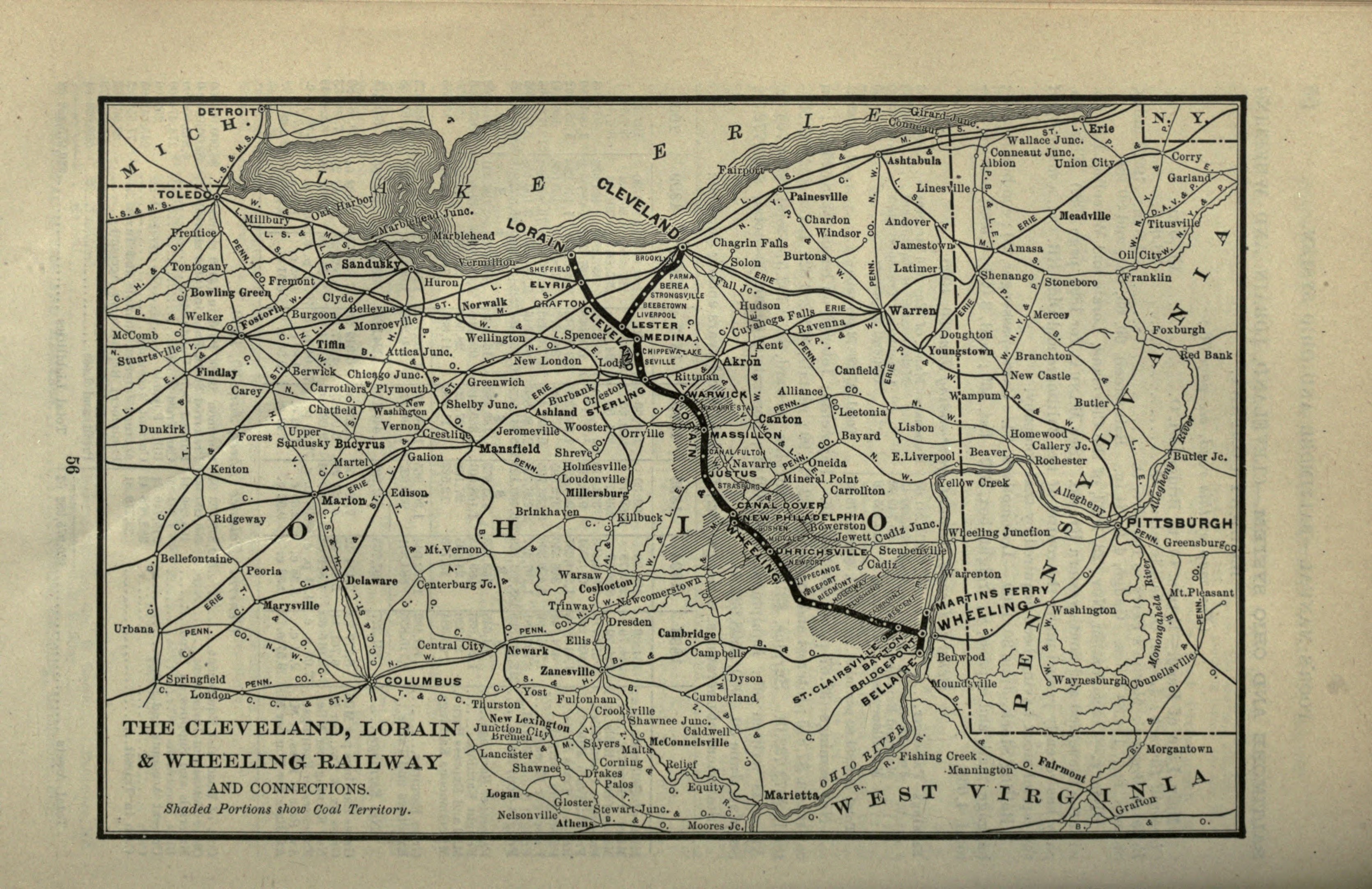
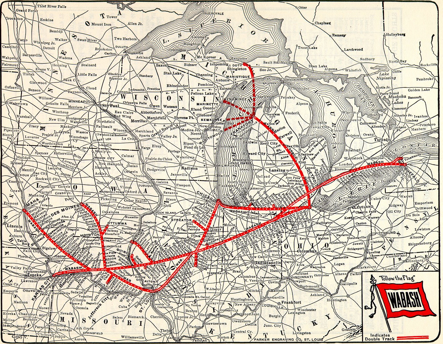
You must be logged in to post a comment.